
Kituwah Interpretive Center
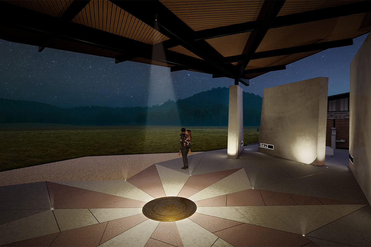
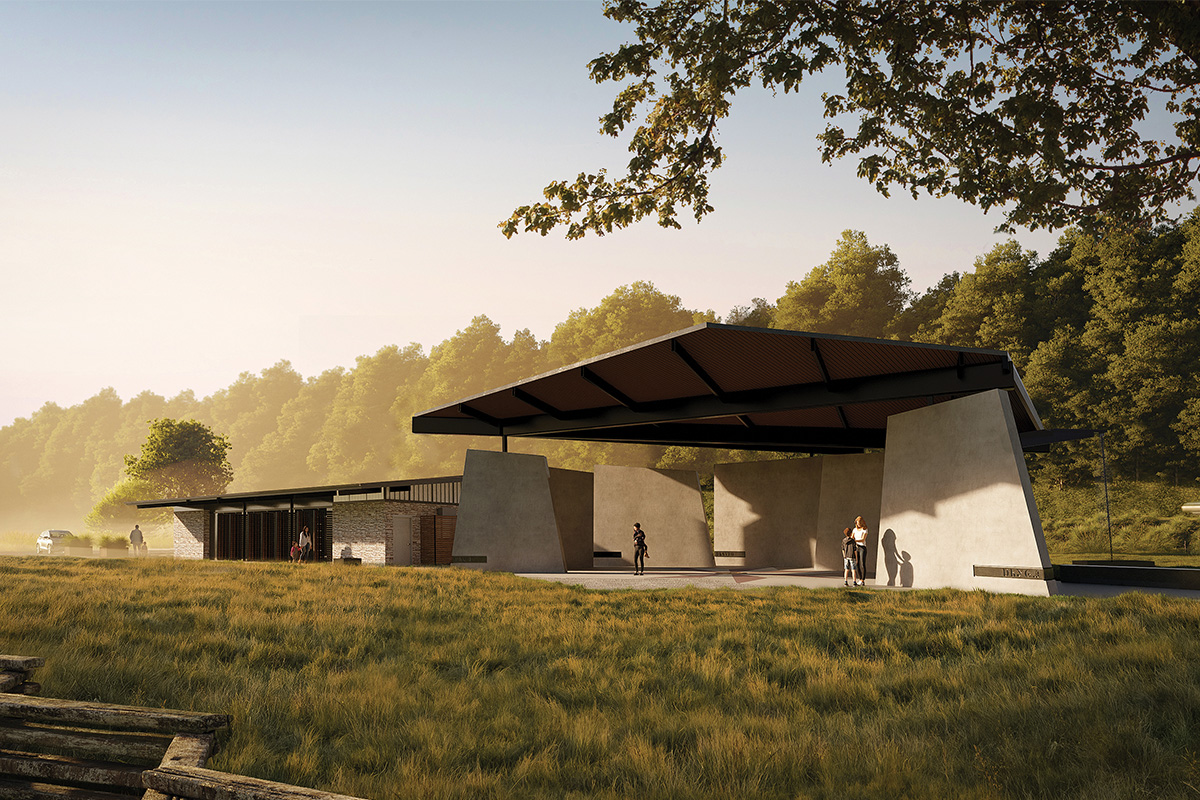
<!-- wp:paragraph --> <p>JAI was tasked by the Eastern Band of Cherokee Indians (EBCI) to design a space to honor their original Cherokee Mother Town mound. In an effort to respect the long-time history of the area the project site was limited to only the boundary of an existing farming shed on the property. The designed Kituwah Interpretive Center is comprised of two open-air structures: a classroom and pavilion joined by a courtyard. Given its location within a Federal Emergency Management Agency (FEMA) floodplain, the center is designed to be “breathable” with materials that can allow and withstand flooding events.</p> <!-- /wp:paragraph --> <!-- wp:paragraph --> <p>The open-air classroom consists of two ground-face concrete block structures connected with an exposed steel overhead structure. It includes a dynamic, colorful screen wall along the northwestern elevation which is viewed from U.S. Highway 19 W (Ela Road) on approach. Located between the block support structures, the classroom features rotating door panels displaying historical text and imagery.</p> <!-- /wp:paragraph --> <!-- wp:paragraph --> <p>An open courtyard anchors the northeast side of the interpretive center, adjacent to a new free-standing pavilion surrounding visitors with seven concrete walls, each signifying one of the seven Cherokee clans. The 15-foot-tall, tapered walls represent sections through the original platform mound, providing a sense of scale for the Kituwah mound in its original state. Each of the seven traditional Cherokee clans are identified in both English and Cherokee on steel plates inset into each wall. A soaring roof structure represents an abstract oak leaf, a Cherokee symbol of the sacred fire which once continuously burned on the mound.</p> <!-- /wp:paragraph -->
Kituwah Interpretive Center
Bryson City, North Carolina
JAI was tasked by the Eastern Band of Cherokee Indians (EBCI) to design a space to honor their original Cherokee Mother Town mound. In an effort to respect the long-time history of the area the project site was limited to only the boundary of an existing farming shed on the property. The designed Kituwah Interpretive Center is comprised of two open-air structures: a classroom and pavilion joined by a courtyard. Given its location within a Federal Emergency Management Agency (FEMA) floodplain, the center is designed to be “breathable” with materials that can allow and withstand flooding events.
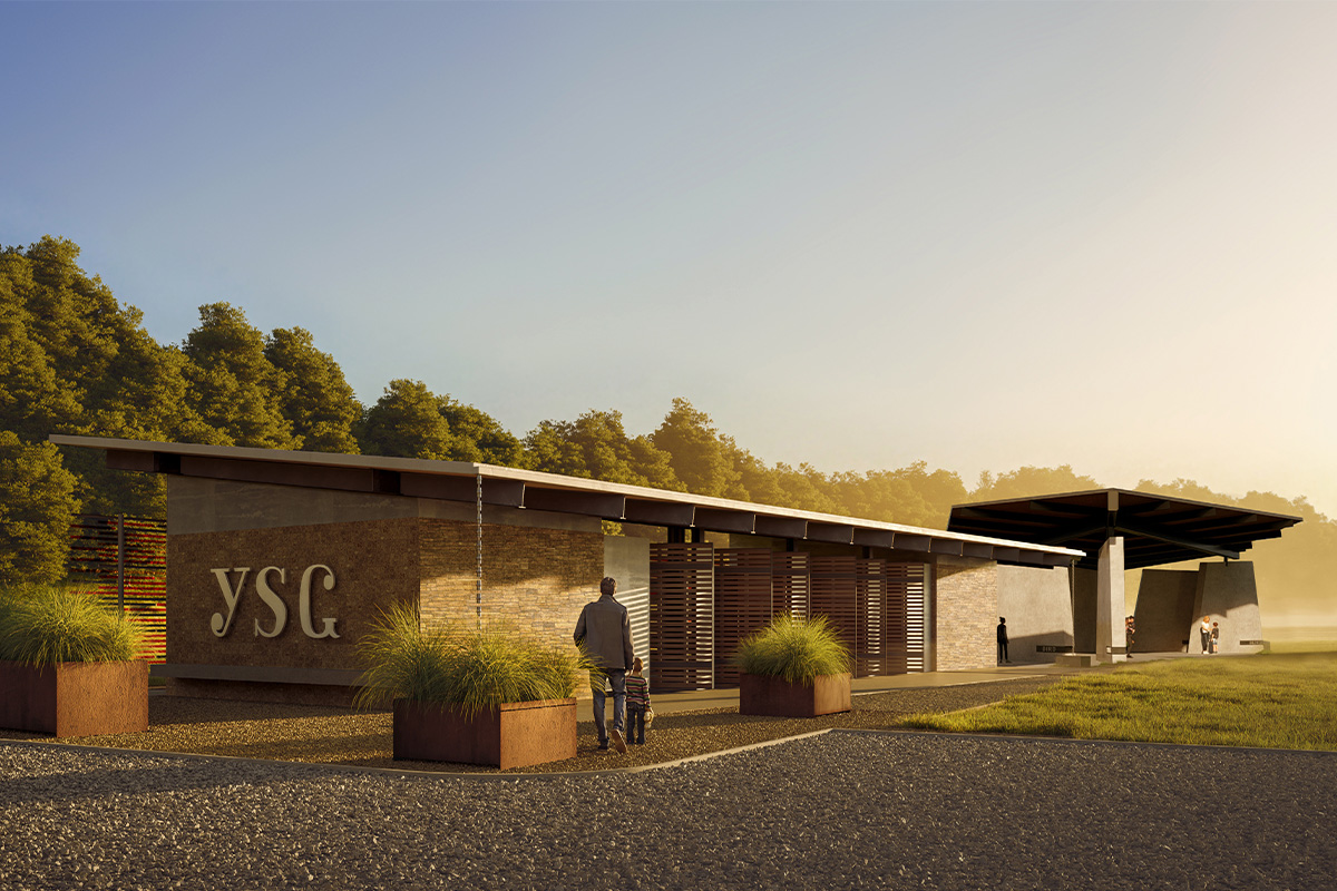
The open-air classroom consists of two ground-face concrete block structures connected with an exposed steel overhead structure. It includes a dynamic, colorful screen wall along the northwestern elevation which is viewed from U.S. Highway 19 W (Ela Road) on approach. Located between the block support structures, the classroom features rotating door panels displaying historical text and imagery.
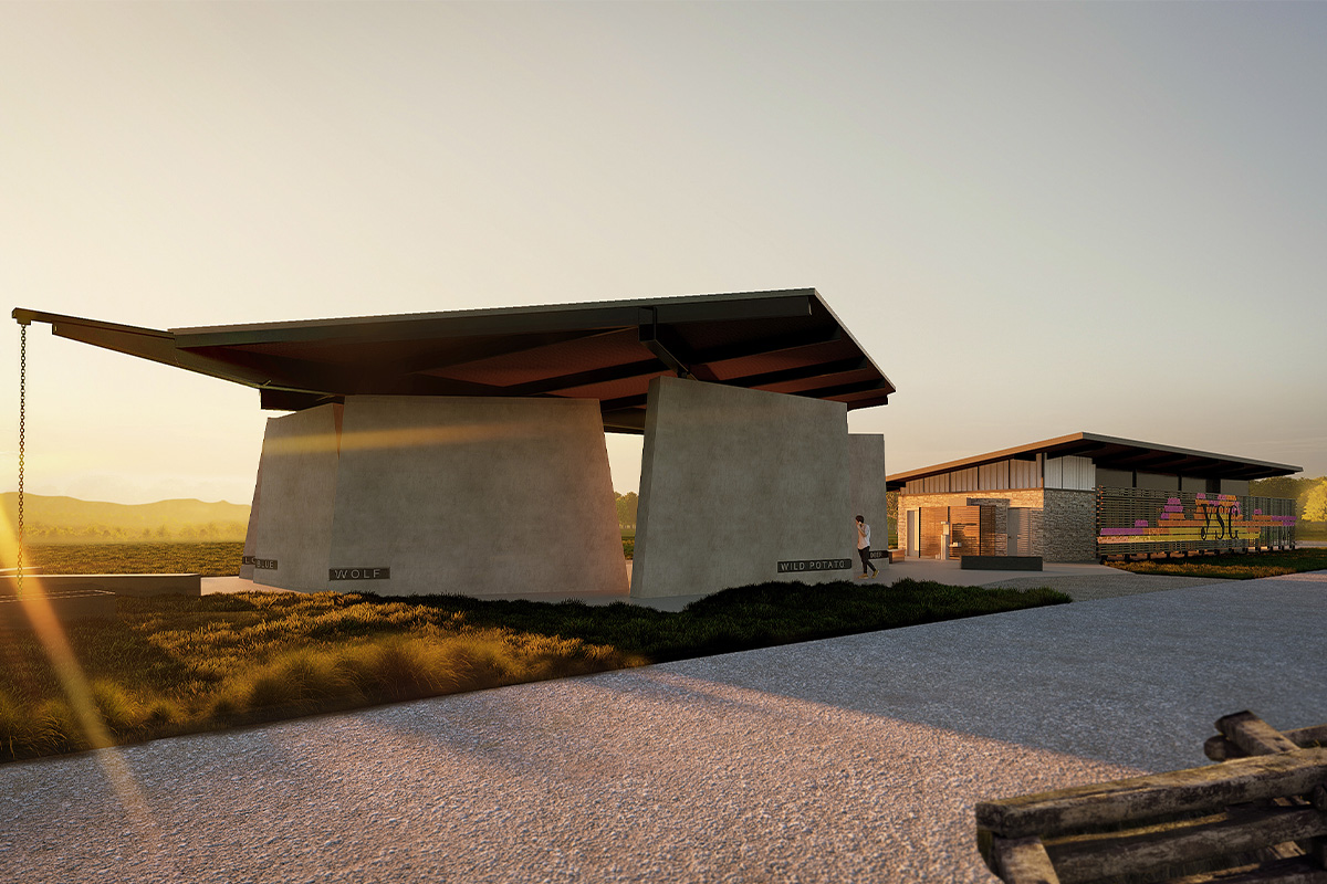
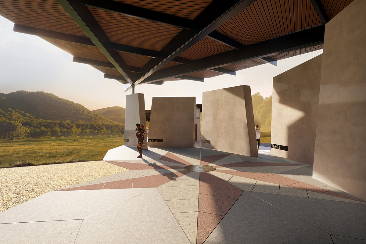
An open courtyard anchors the northeast side of the interpretive center, adjacent to a new free-standing pavilion surrounding visitors with seven concrete walls, each signifying one of the seven Cherokee clans. The 15-foot-tall, tapered walls represent sections through the original platform mound, providing a sense of scale for the Kituwah mound in its original state. Each of the seven traditional Cherokee clans are identified in both English and Cherokee on steel plates inset into each wall. A soaring roof structure represents an abstract oak leaf, a Cherokee symbol of the sacred fire which once continuously burned on the mound.
JAI was tasked by the Eastern Band of Cherokee Indians (EBCI) to design a space to honor their original Cherokee Mother Town mound. In an effort to respect the long-time history of the area the project site was limited to only the boundary of an existing farming shed on the property. The designed Kituwah Interpretive Center is comprised of two open-air structures: a classroom and pavilion joined by a courtyard. Given its location within a Federal Emergency Management Agency (FEMA) floodplain, the center is designed to be “breathable” with materials that can allow and withstand flooding events.
The open-air classroom consists of two ground-face concrete block structures connected with an exposed steel overhead structure. It includes a dynamic, colorful screen wall along the northwestern elevation which is viewed from U.S. Highway 19 W (Ela Road) on approach. Located between the block support structures, the classroom features rotating door panels displaying historical text and imagery.
An open courtyard anchors the northeast side of the interpretive center, adjacent to a new free-standing pavilion surrounding visitors with seven concrete walls, each signifying one of the seven Cherokee clans. The 15-foot-tall, tapered walls represent sections through the original platform mound, providing a sense of scale for the Kituwah mound in its original state. Each of the seven traditional Cherokee clans are identified in both English and Cherokee on steel plates inset into each wall. A soaring roof structure represents an abstract oak leaf, a Cherokee symbol of the sacred fire which once continuously burned on the mound.
BACK TO PORTFOLIO
Kituwah Interpretive Center
Bryson City, North Carolina
Client
Eastern Band of Cherokee Indians
Completion
Ongoing
Cost
Services Provided
Architectural Design
Key Personnel
Key Personnel Test
daryl-johnson-aia-ncarb,emily-haire-ncarb-leed-ap,ryan-orr
AWARDS & RECOGNITION
AIA East Tennessee Citation for Architecture, Unbuilt, 2025
Address(es)
3831 Ela Road,Bryson City,North Carolina,28713
Consultant(s)
Reference(s)
Kituwah Interpretive Center
Bryson City, North Carolina
JAI was tasked by the Eastern Band of Cherokee Indians (EBCI) to design a space to honor their original Cherokee Mother Town mound. In an effort to respect the long-time history of the area the project site was limited to only the boundary of an existing farming shed on the property. The designed Kituwah Interpretive Center is comprised of two open-air structures: a classroom and pavilion joined by a courtyard. Given its location within a Federal Emergency Management Agency (FEMA) floodplain, the center is designed to be “breathable” with materials that can allow and withstand flooding events.
The open-air classroom consists of two ground-face concrete block structures connected with an exposed steel overhead structure. It includes a dynamic, colorful screen wall along the northwestern elevation which is viewed from U.S. Highway 19 W (Ela Road) on approach. Located between the block support structures, the classroom features rotating door panels displaying historical text and imagery.
An open courtyard anchors the northeast side of the interpretive center, adjacent to a new free-standing pavilion surrounding visitors with seven concrete walls, each signifying one of the seven Cherokee clans. The 15-foot-tall, tapered walls represent sections through the original platform mound, providing a sense of scale for the Kituwah mound in its original state. Each of the seven traditional Cherokee clans are identified in both English and Cherokee on steel plates inset into each wall. A soaring roof structure represents an abstract oak leaf, a Cherokee symbol of the sacred fire which once continuously burned on the mound.
PROJECT DETAILS
JAI was tasked by the Eastern Band of Cherokee Indians (EBCI) to design a space to honor their original Cherokee Mother Town mound. In an effort to respect the long-time history of the area the project site was limited to only the boundary of an existing farming shed on the property. The designed Kituwah Interpretive Center is comprised of two open-air structures: a classroom and pavilion joined by a courtyard. Given its location within a Federal Emergency Management Agency (FEMA) floodplain, the center is designed to be “breathable” with materials that can allow and withstand flooding events.
The open-air classroom consists of two ground-face concrete block structures connected with an exposed steel overhead structure. It includes a dynamic, colorful screen wall along the northwestern elevation which is viewed from U.S. Highway 19 W (Ela Road) on approach. Located between the block support structures, the classroom features rotating door panels displaying historical text and imagery.
An open courtyard anchors the northeast side of the interpretive center, adjacent to a new free-standing pavilion surrounding visitors with seven concrete walls, each signifying one of the seven Cherokee clans. The 15-foot-tall, tapered walls represent sections through the original platform mound, providing a sense of scale for the Kituwah mound in its original state. Each of the seven traditional Cherokee clans are identified in both English and Cherokee on steel plates inset into each wall. A soaring roof structure represents an abstract oak leaf, a Cherokee symbol of the sacred fire which once continuously burned on the mound.
BACK TO PORTFOLIO